
Thank you for supporting this site ❤️
Make a donation
Make a donation
Alforja topographic map
Click on the map to display elevation.
Thank you for supporting this site ❤️
Make a donation
Make a donation
About this map
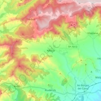
Name: Alforja topographic map, elevation, terrain.
Location: Alforja, Baix Camp, Tarragona, Catalonia, 43365, Spain (41.17833 0.87711 41.24096 1.01739)
Average elevation: 525 m
Minimum elevation: 159 m
Maximum elevation: 1,036 m
Thank you for supporting this site ❤️
Make a donation
Make a donation
Other topographic maps
Click on a map to view its topography, its elevation and its terrain.
Almoster
Spain > Catalonia > Baix Camp > Almoster
Its climate is dry Mediterranean, with low rainfall in the summer and occasionally heavy rainfall in spring and autumn. The driest month is July, with an average rainfall of only 15 mm, and September is usually the wettest, with an average of about 75 mm. The average annual precipitation barely reaches 500 mm.…
Average elevation: 289 m