
Givry topographic map
Interactive map
Click on the map to display elevation.
About this map
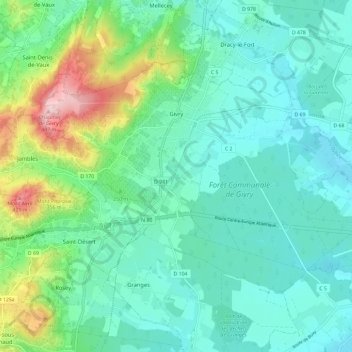
Name: Givry topographic map, elevation, terrain.
Average elevation: 239 m
Minimum elevation: 178 m
Maximum elevation: 448 m
Givry (près du hameau de Russilly, à 446 mètres d'altitude) disposa durant toute la première moitié du XIX siècle d'une station (ou poste télégraphique aérien) du télégraphe Chappe implantée le long de l'« embranchement » reliant Chalon-sur-Saône à la ligne Paris-Toulon, installation qui cessa de fonctionner en 1853, remplacée par la télégraphie électrique.
Other topographic maps
Click on a map to view its topography, its elevation and its terrain.
Hameau du Château
France > Bourgogne-Franche-Comté > Saône-et-Loire > Rully
Hameau du Château, Rully, Chalon-sur-Saône, Saône-et-Loire, Bourgogne-Franche-Comté, France métropolitaine, 71150, France
Average elevation: 275 m
Bois de Loyse
France > Bourgogne-Franche-Comté > Saône-et-Loire > La Chapelle-de-Guinchay
Bois de Loyse, La Chapelle-de-Guinchay, Mâcon, Saône-et-Loire, Bourgogne-Franche-Comté, France métropolitaine, 71570, France
Average elevation: 212 m
Issy-l'Évêque
France > Bourgogne-Franche-Comté > Saône-et-Loire
Issy-l'Évêque, Charolles, Saône-et-Loire, Bourgogne-Franche-Comté, France métropolitaine, 71760, France
Average elevation: 339 m
Saint-Gengoux-le-National
France > Bourgogne-Franche-Comté > Saône-et-Loire
Saint-Gengoux-le-National, Chalon-sur-Saône, Saône-et-Loire, Bourgogne-Franche-Comté, France métropolitaine, 71460, France
Average elevation: 262 m
Saint-Vincent-Bragny
France > Bourgogne-Franche-Comté > Saône-et-Loire
Saint-Vincent-Bragny, Charolles, Saône-et-Loire, Bourgogne-Franche-Comté, France métropolitaine, 71430, France
Average elevation: 285 m
Cluny
France > Bourgogne-Franche-Comté > Saône-et-Loire
Cluny, Mâcon, Saône-et-Loire, Bourgogne-Franche-Comté, France métropolitaine, 71250, France
Average elevation: 348 m