
Ebenalp topographic map
Interactive map
Click on the map to display elevation.
About this map
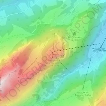
Name: Ebenalp topographic map, elevation, terrain.
Average elevation: 1,233 m
Minimum elevation: 856 m
Maximum elevation: 1,906 m
Die Ebenalp ist das nördliche Ende des Alpsteins und liegt mit seiner Höhe von 1644 m ü. M. auf einem Grat, der sich vom Säntisgipfel zum Schäfler erstreckt.
Other topographic maps
Click on a map to view its topography, its elevation and its terrain.
Wasserauen
Schweiz > Appenzell Innerrhoden > Schwende-Rüte
Wasserauen, Schwende, Schwende-Rüte, Appenzell Innerrhoden, 9057, Schweiz
Average elevation: 1,185 m