
Thank you for supporting this site ❤️
Make a donation
Make a donation
Erith topographic map
Click on the map to display elevation.
Thank you for supporting this site ❤️
Make a donation
Make a donation
About this map
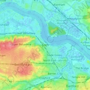
Name: Erith topographic map, elevation, terrain.
Location: Erith, London, Greater London, England, DA8 1SP, United Kingdom (51.44082 0.13923 51.52082 0.21923)
Average elevation: 17 m
Minimum elevation: -8 m
Maximum elevation: 73 m
Thank you for supporting this site ❤️
Make a donation
Make a donation
Other topographic maps
Click on a map to view its topography, its elevation and its terrain.
Thank you for supporting this site ❤️
Make a donation
Make a donation
Gorilla Circus Regents Park Flying Trapeze School
United Kingdom > England > London > Camden Town
Average elevation: 41 m
Thank you for supporting this site ❤️
Make a donation
Make a donation
Thank you for supporting this site ❤️
Make a donation
Make a donation
Thank you for supporting this site ❤️
Make a donation
Make a donation