
Make a donation
Union County topographic map
Click on the map to display elevation.
Make a donation
Union County
Much of Union County is relatively flat and low-lying. Only in the northwestern corner does any significant relief appear as the Watchung Mountains cross the county. It is there that highest elevations, two areas approximately 560 feet (170 m) above sea level, are found in Berkeley Heights. The lowest elevation is sea level along the eastern shore at the Arthur Kill.
Make a donation
About this map
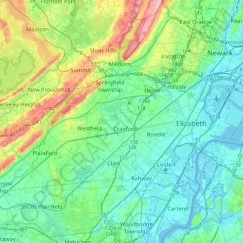
Name: Union County topographic map, elevation, terrain.
Location: Union County, New Jersey, United States (40.59190 -74.46335 40.73933 -74.13777)
Average elevation: 45 m
Minimum elevation: -5 m
Maximum elevation: 202 m
Make a donation
Other topographic maps
Click on a map to view its topography, its elevation and its terrain.
Deer Park Pond
United States > New Jersey > Warren County > Allamuchy Township
Average elevation: 282 m
Make a donation
Fairview Knolls
United States > New Jersey > Middlesex County > East Brunswick Township
Average elevation: 31 m
Make a donation
Woodbridge
United States > New Jersey > Middlesex County > Woodbridge Township
Average elevation: 16 m
Robbinsville
United States > New Jersey > Mercer County > Robbinsville Township
Average elevation: 32 m
Whitehouse Station
United States > New Jersey > Hunterdon County > Readington Township
Average elevation: 61 m
Make a donation
Chadwick Beach
United States > New Jersey > Ocean County > Toms River > Dover Beaches North
Average elevation: 0 m
Delaware Water Gap
United States > New Jersey > Warren County > Hardwick Township > Dunnfield
Average elevation: 246 m
Make a donation
Harker's Hollow Heights
United States > New Jersey > Warren County > Lopatcong Township
Average elevation: 161 m
Red Rock Lake
United States > New Jersey > Hunterdon County > Rockefellows Mills
Average elevation: 42 m
Make a donation
Princeton Colonial Park
United States > New Jersey > Mercer County > West Windsor
Average elevation: 29 m
Sayreville Junction
United States > New Jersey > Middlesex County > Sayreville
Average elevation: 17 m
Make a donation
Candlewood
United States > New Jersey > Monmouth County > Howell Township > Candlewood
Average elevation: 33 m
High Crest Lake
United States > New Jersey > Passaic County > West Milford > Smiths Mills
Average elevation: 219 m
Make a donation
Make a donation
Columbia Lake
United States > New Jersey > Warren County > Knowlton Township > Warrington
Average elevation: 117 m
Swinefield Bridge
United States > New Jersey > Morris County > East Hanover > Swinefield Bridge
Average elevation: 63 m
South River
United States > New Jersey > Middlesex County > South River > South River
Average elevation: 19 m
Make a donation
Make a donation
Butterworth Farms
United States > New Jersey > Morris County > Morris Township
Average elevation: 182 m