
Thank you for supporting this site ❤️
Make a donation
Make a donation
Tramore topographic map
Click on the map to display elevation.
Thank you for supporting this site ❤️
Make a donation
Make a donation
About this map
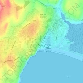
Name: Tramore topographic map, elevation, terrain.
Location: Tramore, County Waterford, Munster, Ireland (52.14528 -7.17557 52.17886 -7.13161)
Average elevation: 28 m
Minimum elevation: 0 m
Maximum elevation: 91 m
Thank you for supporting this site ❤️
Make a donation
Make a donation
Other topographic maps
Click on a map to view its topography, its elevation and its terrain.