
Make a donation
Batakundi topographic map
Click on the map to display elevation.
Make a donation
About this map
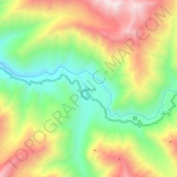
Name: Batakundi topographic map, elevation, terrain.
Location: Batakundi, Khyber Pakhtunkhwa, Pakistan (34.89058 73.73746 34.97058 73.81746)
Average elevation: 3,344 m
Minimum elevation: 2,491 m
Maximum elevation: 4,553 m
Make a donation
Other topographic maps
Click on a map to view its topography, its elevation and its terrain.
Kabal Tehsil
Pakistan > Khyber Pakhtunkhwa > Swat District
Kabal Town is located at 34°47′N 72°17′E / 34.783°N 72.283°E / 34.783; 72.283 at an altitude of 845 metres (2,772 ft).
Average elevation: 1,477 m
Tarbela Dam
Pakistan > Khyber Pakhtunkhwa > Haripur District
Tarbela Reservoir is 80.5 kilometres (50.0 mi) long, with a surface area of 250 square kilometres (97 sq mi). The reservoir initially stored 11,600,000 acre-feet (14.3 km3) of water, with a live storage of 9,700,000 acre-feet (12.0 km3), though this figure has been reduced over the subsequent 35 years of…
Average elevation: 451 m
Mastuj Tehsil
Pakistan > Khyber Pakhtunkhwa > Chitrāl District
Mastuj (Urdu: مستوج) is a tehsil of Upper Chitral District in Khyber-Pakhtunkhwa province of Pakistan; Mastuj is the principal settlement. It is located at 36°17'0N 72°31'0E with an altitude of 2359 metres (7742 feet). There are ruins of old fort built originally in 18th century and reconstructed several times.
Average elevation: 4,143 m
Chitrāl District
Chitral is connected to the rest of Pakistan by two major road routes, the Lowari Pass (el. 10,230 ft.) from Dir and Shandur Top (elevation 12,200 ft.) from Gilgit. Both routes used to be closed in winter, but circa 2017 the highway Lowari Tunnel under the Lowari Pass opened to vehicular traffic for at least…
Average elevation: 3,729 m
Make a donation