
Tanos topographic map
Interactive map
Click on the map to display elevation.
About this map
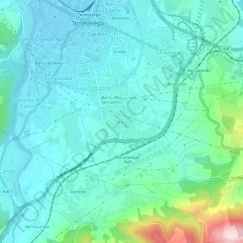
Name: Tanos topographic map, elevation, terrain.
Location: Tanos, Torrelavega, Cantabria, 39300, España (43.31246 -4.06380 43.35246 -4.02380)
Average elevation: 87 m
Minimum elevation: 12 m
Maximum elevation: 433 m
Tanos se encuentra a una altitud de 26 metros sobre el nivel del mar, y dista 26 kilómetros de Santander.
Other topographic maps
Click on a map to view its topography, its elevation and its terrain.
El Valle
España > Cantabria > Torrelavega > Sierrapando
El Valle, Sierrapando, Torrelavega, Cantabria, 39300, España
Average elevation: 58 m
Barrio Mies de Coterios
España > Cantabria > Torrelavega > Tanos
Barrio Mies de Coterios, Tanos, Torrelavega, Cantabria, 39300, España
Average elevation: 70 m
La Montaña
España > Cantabria > Torrelavega
La Montaña, Torrelavega, Cantabria, 39300, España
Average elevation: 200 m
Campuzano
España > Cantabria > Torrelavega
Campuzano, Torrelavega, Cantabria, 39300, España
Average elevation: 57 m
Barreda
España > Cantabria > Torrelavega > Barreda
Barreda, Torrelavega, Besaya, Cantabria, 39300, España
Average elevation: 38 m