
Thank you for supporting this site ❤️
Make a donation
Make a donation
Bear Ridge topographic map
Click on the map to display elevation.
Thank you for supporting this site ❤️
Make a donation
Make a donation
About this map
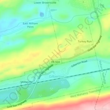
Name: Bear Ridge topographic map, elevation, terrain.
Average elevation: 389 m
Minimum elevation: 321 m
Maximum elevation: 515 m
Thank you for supporting this site ❤️
Make a donation
Make a donation
Other topographic maps
Click on a map to view its topography, its elevation and its terrain.
Shenandoah Heights
United States > Pennsylvania > Schuylkill County > West Mahanoy Township
Average elevation: 470 m
Lower Brownsville
United States > Pennsylvania > Schuylkill County > West Mahanoy Township
Average elevation: 425 m