
Thank you for supporting this site ❤️
Make a donation
Make a donation
Moose River topographic map
Click on the map to display elevation.
Thank you for supporting this site ❤️
Make a donation
Make a donation
About this map
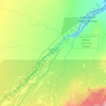
Name: Moose River topographic map, elevation, terrain.
Average elevation: 36 m
Minimum elevation: -4 m
Maximum elevation: 159 m
Thank you for supporting this site ❤️
Make a donation
Make a donation
Other topographic maps
Click on a map to view its topography, its elevation and its terrain.
Ellery Lake
Canada > Ontario > Cochrane District > Unorganized North Cochrane
Average elevation: 350 m
Thank you for supporting this site ❤️
Make a donation
Make a donation
Driftwood
Canada > Ontario > Cochrane District > Unorganized North Cochrane > Driftwood
Average elevation: 272 m
Thank you for supporting this site ❤️
Make a donation
Make a donation