
Winterberg topographic map
Interactive map
Click on the map to display elevation.
About this map
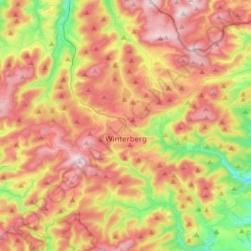
Name: Winterberg topographic map, elevation, terrain.
Average elevation: 627 m
Minimum elevation: 390 m
Maximum elevation: 844 m
Other topographic maps
Click on a map to view its topography, its elevation and its terrain.
Ruhrquelle
Alemanha > Renânia do Norte-Vestfália > Hochsauerlandkreis > Winterberg > Elkeringhausen
Ruhrquelle, L 740, Elkeringhausen, Winterberg, Hochsauerlandkreis, Renânia do Norte-Vestfália, 59955, Alemanha
Average elevation: 645 m