
Saint Paul topographic map
Interactive map
Click on the map to display elevation.
About this map
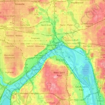
Name: Saint Paul topographic map, elevation, terrain.
Location: Saint Paul, Ramsey County, Minnesota, États-Unis d'Amérique (44.88727 -93.20781 44.99202 -93.00431)
Average elevation: 268 m
Minimum elevation: 207 m
Maximum elevation: 334 m
Other topographic maps
Click on a map to view its topography, its elevation and its terrain.
Saint Paul
États-Unis d'Amérique > Minnesota > Ramsey County > Saint Paul
Saint Paul, Ramsey County, Minnesota, 55101, États-Unis d'Amérique
Average elevation: 273 m