
Nufenenpass topographic map
Interactive map
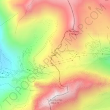
Click on the map to display elevation.
About this map
Name: Nufenenpass topographic map, elevation, terrain.
Average elevation: 2,426 m
Minimum elevation: 1,916 m
Maximum elevation: 2,844 m
Der Nufenenpass (italienisch Passo della Novena) ist ein 2439 m ü. M. hoher Gebirgspass in der Schweiz, der die Kantone Wallis im Westen und Tessin im Osten verbindet sowie die Gotthard-Gruppe im Norden von der Leone-Gruppe im Süden trennt. Über den Sattelpunkt verläuft der Vier-Quellen-Weg, die Passstraße allerdings etwas weiter nördlich und höher.
Other topographic maps
Click on a map to view its topography, its elevation and its terrain.
Bedretto
Schweiz > Tessin > Bezirk Leventina > Bedretto
Bedretto, Circolo di Airolo, Bezirk Leventina, Tessin, 6781, Schweiz
Average elevation: 2,250 m