
Nanos topographic map
Interactive map
Click on the map to display elevation.
About this map
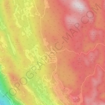
Name: Nanos topographic map, elevation, terrain.
Location: Nanos, Wippach, Slowenien (45.79946 13.99930 45.83946 14.03930)
Average elevation: 904 m
Minimum elevation: 351 m
Maximum elevation: 1,192 m
Der östliche Rand des Karstplateaus fällt vom Berg Pleša (1262 m) steil zum Razdrto ab, nach Westen senkt sich der Bergzug allmählich auf 500 m ab. Im Nordosten grenzt er an den Höhenzug des Birnbaumer Waldes (Hrušica).