
Mat topographic map
Interactive map
Click on the map to display elevation.
About this map
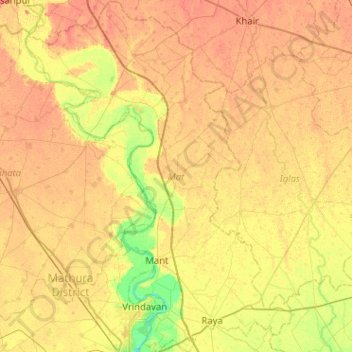
Name: Mat topographic map, elevation, terrain.
Location: Mat, Mathura, Uttar Pradesh, India (27.51505 77.52129 27.96636 77.90800)
Average elevation: 182 m
Minimum elevation: 160 m
Maximum elevation: 195 m
Other topographic maps
Click on a map to view its topography, its elevation and its terrain.
Beel Akbarpur
India > Uttar Pradesh > Beel Akbarpur
Beel Akbarpur, Ghaziabad, Uttar Pradesh, 201314, India
Average elevation: 208 m
Palia
India > Uttar Pradesh > Palia
Palia, Kheri, Uttar Pradesh, 262902, India
Average elevation: 157 m
Ganges
Ganges, Ghāzīpur, Ghazipur, Uttar Pradesh, 249304, India
Average elevation: 1,626 m
Dibai
India > Uttar Pradesh > Dibai
Dibai, Debai, Bulandshahr, Uttar Pradesh, 202393, India
Average elevation: 190 m