
Thank you for supporting this site ❤️
Make a donation
Make a donation
Dingestow topographic map
Click on the map to display elevation.
Thank you for supporting this site ❤️
Make a donation
Make a donation
About this map
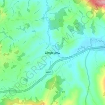
Name: Dingestow topographic map, elevation, terrain.
Location: Dingestow, Monmouthshire, Wales, NP25 4DP, United Kingdom (51.76753 -2.80868 51.80753 -2.76868)
Average elevation: 64 m
Minimum elevation: 25 m
Maximum elevation: 203 m
Thank you for supporting this site ❤️
Make a donation
Make a donation
Other topographic maps
Click on a map to view its topography, its elevation and its terrain.
Thank you for supporting this site ❤️
Make a donation
Make a donation
Thank you for supporting this site ❤️
Make a donation
Make a donation