
Pool Department topographic map
Interactive map
Click on the map to display elevation.
About this map
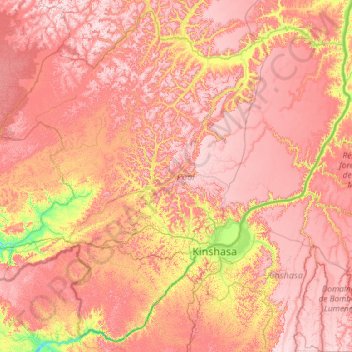
Name: Pool Department topographic map, elevation, terrain.
Location: Pool Department, Congo-Brazzaville (-4.92214 13.86027 -2.71746 16.21456)
Average elevation: 509 m
Minimum elevation: 139 m
Maximum elevation: 837 m
Other topographic maps
Click on a map to view its topography, its elevation and its terrain.
Mateve
Congo-Brazzaville > Kouilou Department > Hinda
Mateve, Hinda, Ngoyo, Kouilou Department, Congo-Brazzaville
Average elevation: 14 m
Cuvette-Ouest Department
Cuvette-Ouest Department, Congo-Brazzaville
Average elevation: 453 m
Kakamoeka
Congo-Brazzaville > Kouilou > Kakamoeka
Kakamoeka, Kouilou, Congo-Brazzaville
Average elevation: 110 m