
Crete topographic map
Interactive map
Click on the map to display elevation.
About this map
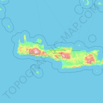
Name: Crete topographic map, elevation, terrain.
Location: Crete, Region of Crete, Greece (34.92121 23.51448 35.69578 26.31897)
Average elevation: 57 m
Minimum elevation: 0 m
Maximum elevation: 2,440 m
The island is mostly mountainous, and its character is defined by a high mountain range crossing from west to east. It includes Crete's highest point, Mount Ida, and the range of the White Mountains (Lefka Ori) with 30 summits above 2,000 metres (6,600 ft) in altitude and the Samaria Gorge, a World Biosphere Reserve. Crete forms a significant part of the economy and cultural heritage of Greece, while retaining its own local cultural traits (such as its own poetry and music). The Nikos Kazantzakis airport at Heraklion and the Daskalogiannis airport at Chania serve international travelers. The Minoan palace at Knossos is also located in Heraklion.
Other topographic maps
Click on a map to view its topography, its elevation and its terrain.
Vachos
Greece > Region of Crete > Heraklion Regional Unit
Vachos, Municipality of Viannos, Heraklion Regional Unit, Region of Crete, 700 04, Greece
Average elevation: 673 m
Παλαιόσουδα
Greece > Region of Crete > Chania Regional Unit > Marathi
Παλαιόσουδα, Marathi, Municipality of Chania, Chania Regional Unit, Region of Crete, Greece
Average elevation: 11 m
Rethymnon
Greece > Region of Crete > Rethymno Regional Unit
Rethymnon, Municipality of Rethymnon, Rethymno Regional Unit, Region of Crete, 741 31, Greece
Average elevation: 204 m
Macheri
Greece > Region of Crete > Chania Regional Unit
Macheri, Municipality of Apokoronas, Chania Regional Unit, Region of Crete, 730 03, Greece
Average elevation: 170 m
Margelion
Greece > Region of Crete > Lasithi Regional Unit > Agios Nikolaos Municipal Unit
Margelion, Community of Mesa Lakkonia, Agios Nikolaos Municipal Unit, Municipality of Agios Nikolaos, Lasithi Regional Unit, Region of Crete, 721 00, Greece
Average elevation: 293 m
Lato
Greece > Region of Crete > Lasithi Regional Unit > Agios Nikolaos Municipal Unit > Margelion
Lato, Κριτσᾶς - Λακκωνίων, Margelion, Community of Kritsa, Agios Nikolaos Municipal Unit, Municipality of Agios Nikolaos, Lasithi Regional Unit, Region of Crete, 72100, Greece
Average elevation: 262 m