
Rockwall topographic map
Interactive map
Click on the map to display elevation.
About this map
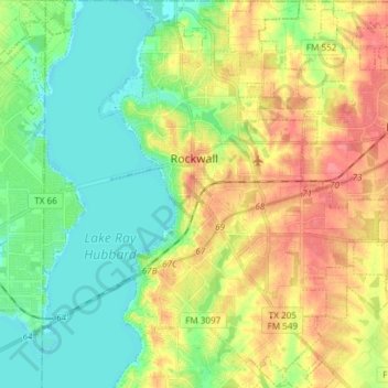
Name: Rockwall topographic map, elevation, terrain.
Location: Rockwall, Rockwall County, Texas, 75087, United States (32.85730 -96.48919 32.98245 -96.34975)
Average elevation: 156 m
Minimum elevation: 131 m
Maximum elevation: 191 m
Other topographic maps
Click on a map to view its topography, its elevation and its terrain.
Lake Ray Hubbard
United States > Texas > Rockwall County > Rockwall
Lake Ray Hubbard, Rockwall, Rockwall County, Texas, United States
Average elevation: 153 m
Royse City
United States > Texas > Rockwall County > Royse City > Royse City
Royse City, Rockwall County, Texas, 75189, United States
Average elevation: 170 m
Heath
United States > Texas > Rockwall County > Heath
Heath, Rockwall County, Texas, United States
Average elevation: 146 m
Fate
United States > Texas > Rockwall County
Fate, Rockwall County, Texas, 75132, United States
Average elevation: 173 m
Royse City
United States > Texas > Rockwall County
Royse City, Rockwall County, Texas, 75189, United States
Average elevation: 172 m