
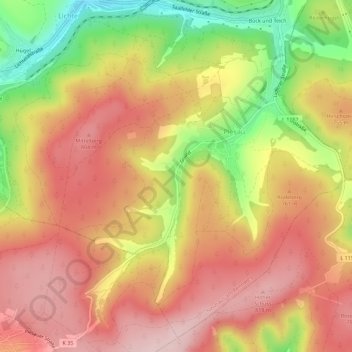
Piesau topographic map
Interactive map
Click on the map to display elevation.
About this map
Name: Piesau topographic map, elevation, terrain.
Average elevation: 727 m
Minimum elevation: 573 m
Maximum elevation: 828 m
Other topographic maps
Click on a map to view its topography, its elevation and its terrain.
Steinheid
Deutschland > Thüringen > Landkreis Sonneberg > Neuhaus am Rennweg
Steinheid, Neuhaus am Rennweg, Landkreis Sonneberg, Thüringen, Deutschland
Average elevation: 755 m
Scheibe-Alsbach
Deutschland > Thüringen > Landkreis Sonneberg > Neuhaus am Rennweg
Scheibe-Alsbach, Neuhaus am Rennweg, Landkreis Sonneberg, Thüringen, Deutschland
Average elevation: 740 m
Siegmundsburg
Deutschland > Thüringen > Landkreis Sonneberg > Neuhaus am Rennweg
Siegmundsburg, Neuhaus am Rennweg, Landkreis Sonneberg, Thüringen, Deutschland
Average elevation: 738 m
Lichte
Deutschland > Thüringen > Landkreis Sonneberg > Neuhaus am Rennweg
Lichte, Neuhaus am Rennweg, Landkreis Sonneberg, Thüringen, 98724, Deutschland
Average elevation: 622 m