
Moutiers topographic map
Interactive map
Click on the map to display elevation.
About this map
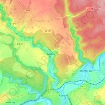
Name: Moutiers topographic map, elevation, terrain.
Average elevation: 239 m
Minimum elevation: 176 m
Maximum elevation: 304 m
Other topographic maps
Click on a map to view its topography, its elevation and its terrain.
Blesse
Frankrijk > Grand Est > Meurthe-et-Moselle > Boismont
Blesse, Boismont, Val-de-Briey, Meurthe-et-Moselle, Grand Est, Metropolitaans Frankrijk, 54620, Frankrijk
Average elevation: 298 m
Le Meuse
Frankrijk > Grand Est > Meurthe-et-Moselle > Tantonville
Le Meuse, Tantonville, Nancy, Meurthe-et-Moselle, Grand Est, Metropolitaans Frankrijk, 54116, Frankrijk
Average elevation: 291 m
Saint-Firmin
Frankrijk > Grand Est > Meurthe-et-Moselle
Saint-Firmin, Nancy, Meurthe-et-Moselle, Grand Est, Metropolitaans Frankrijk, 54930, Frankrijk
Average elevation: 296 m
Seichamps
Frankrijk > Grand Est > Meurthe-et-Moselle
Seichamps, Nancy, Meurthe-et-Moselle, Grand Est, Metropolitaans Frankrijk, 54280, Frankrijk
Average elevation: 245 m
Azelot
Frankrijk > Grand Est > Meurthe-et-Moselle
Azelot, Nancy, Meurthe-et-Moselle, Grand Est, Metropolitaans Frankrijk, 54210, Frankrijk
Average elevation: 297 m
Aboncourt
Frankrijk > Grand Est > Meurthe-et-Moselle > Aboncourt
Aboncourt, Toul, Meurthe-et-Moselle, Grand Est, Metropolitaans Frankrijk, 54115, Frankrijk
Average elevation: 373 m
Villerupt
Frankrijk > Grand Est > Meurthe-et-Moselle > Villerupt
Villerupt, Briey, Meurthe-et-Moselle, Grand Est, Metropolitaans Frankrijk, 54190, Frankrijk
Average elevation: 386 m
Andilly
Frankrijk > Grand Est > Meurthe-et-Moselle > Andilly
Andilly, Toul, Meurthe-et-Moselle, Grand Est, Metropolitaans Frankrijk, 54200, Frankrijk
Average elevation: 231 m
Nancy
Frankrijk > Grand Est > Meurthe-et-Moselle
Nancy, Meurthe-et-Moselle, Grand Est, Metropolitaans Frankrijk, Frankrijk
Average elevation: 230 m
Domèvre-en-Haye
Frankrijk > Grand Est > Meurthe-et-Moselle > Domèvre-en-Haye
Domèvre-en-Haye, Toul, Meurthe-et-Moselle, Grand Est, Metropolitaans Frankrijk, 54385, Frankrijk
Average elevation: 264 m
Saint-Martin
Frankrijk > Grand Est > Meurthe-et-Moselle
Saint-Martin, Lunéville, Meurthe-et-Moselle, Grand Est, Metropolitaans Frankrijk, 54450, Frankrijk
Average elevation: 262 m
Liverdun
Frankrijk > Grand Est > Meurthe-et-Moselle
Liverdun, Nancy, Meurthe-et-Moselle, Grand Est, Metropolitaans Frankrijk, 54460, Frankrijk
Average elevation: 280 m