
Thank you for supporting this site ❤️
Make a donation
Make a donation
Poompuhar topographic map
Click on the map to display elevation.
Thank you for supporting this site ❤️
Make a donation
Make a donation
About this map
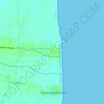
Name: Poompuhar topographic map, elevation, terrain.
Location: Poompuhar, Sirkali, Mayiladuthurai, Tamil Nadu, 609105, India (11.12529 79.83373 11.16529 79.87373)
Average elevation: 2 m
Minimum elevation: -2 m
Maximum elevation: 8 m
Thank you for supporting this site ❤️
Make a donation
Make a donation
Other topographic maps
Click on a map to view its topography, its elevation and its terrain.
Cauvery
India > Tamil Nadu > Sirkali > Alangadu
The Kaveri (also known as Cauvery, the anglicized name) is one of the major Indian rivers flowing through the states of Karnataka and Tamil Nadu. The Kaveri River rises at Talakaveri in the Brahmagiri range in the Western Ghats, Kodagu district of the state of Karnataka, at an elevation of 1,341 m above mean…
Average elevation: 7 m