
Davis County topographic map
Interactive map
Click on the map to display elevation.
About this map
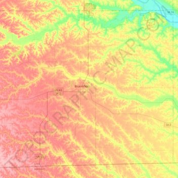
Name: Davis County topographic map, elevation, terrain.
Location: Davis County, Iowa, United States of America (40.59083 -92.63982 40.89941 -92.17916)
Average elevation: 251 m
Minimum elevation: 182 m
Maximum elevation: 306 m
Other topographic maps
Click on a map to view its topography, its elevation and its terrain.
Bancroft
United States of America > Iowa > Bancroft
Bancroft, Kossuth County, Iowa, United States of America
Average elevation: 354 m
Keystone
United States of America > Iowa > Keystone
Keystone, Benton County, Iowa, 52249, United States of America
Average elevation: 272 m
Clarke County
United States of America > Iowa
Clarke County, Iowa, United States of America
Average elevation: 331 m
Woodbury County
United States of America > Iowa
Woodbury County, Iowa, United States of America
Average elevation: 376 m
Agency
United States of America > Iowa > Agency
Agency, Iowa, 52530, United States of America
Average elevation: 243 m
Dewar
United States of America > Iowa > Dewar
Dewar, Black Hawk County, Iowa, 50623, United States of America
Average elevation: 279 m
Iowa County
United States of America > Iowa
Iowa County, Iowa, United States of America
Average elevation: 249 m