
Ross County topographic map
Interactive map
Click on the map to display elevation.
About this map
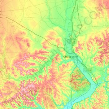
Name: Ross County topographic map, elevation, terrain.
Location: Ross County, Ohio, United States of America (39.16781 -83.39437 39.51597 -82.74069)
Average elevation: 257 m
Minimum elevation: 165 m
Maximum elevation: 409 m
Other topographic maps
Click on a map to view its topography, its elevation and its terrain.
Parma
United States of America > Ohio > Parma
Parma, Cuyahoga County, Ohio, United States of America
Average elevation: 282 m
Rocky River
United States of America > Ohio > Rocky River
Rocky River, Cuyahoga County, Ohio, 44116, United States of America
Average elevation: 205 m
Summit County
United States of America > Ohio
Summit County, Ohio, United States of America
Average elevation: 327 m
Glouster
United States of America > Ohio > Glouster
Glouster, Athens County, Ohio, 45732, United States of America
Average elevation: 235 m