
Noun topographic map
Interactive map
Click on the map to display elevation.
About this map
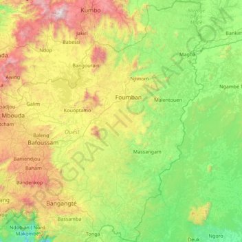
Name: Noun topographic map, elevation, terrain.
Location: Noun, Région de l'Ouest, Cameroun (4.92397 10.45625 6.26439 11.31537)
Average elevation: 1,007 m
Minimum elevation: 312 m
Maximum elevation: 2,971 m
Other topographic maps
Click on a map to view its topography, its elevation and its terrain.
Bangou
Cameroun > Région de l'Ouest > Hauts-Plateaux
Bangou, Hauts-Plateaux, Région de l'Ouest, Cameroun
Average elevation: 1,576 m