
Thank you for supporting this site ❤️
Make a donation
Make a donation
Les Prioux topographic map
Click on the map to display elevation.
Thank you for supporting this site ❤️
Make a donation
Make a donation
About this map
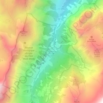
Name: Les Prioux topographic map, elevation, terrain.
Average elevation: 2,233 m
Minimum elevation: 1,529 m
Maximum elevation: 3,006 m
Thank you for supporting this site ❤️
Make a donation
Make a donation
Other topographic maps
Click on a map to view its topography, its elevation and its terrain.
Lac des Vaches
France > Auvergne-Rhône-Alpes > Savoie > Pralognan-la-Vanoise
Average elevation: 2,510 m
Glacier du Génépy
France > Auvergne-Rhône-Alpes > Savoie > Pralognan-la-Vanoise
Average elevation: 3,088 m
Glacier de la Grande Casse
France > Auvergne-Rhône-Alpes > Savoie > Pralognan-la-Vanoise
Average elevation: 2,896 m
Glacier de la Grande Casse
France > Auvergne-Rhône-Alpes > Savoie > Pralognan-la-Vanoise
Average elevation: 2,896 m
Thank you for supporting this site ❤️
Make a donation
Make a donation