
Swabia topographic map
Interactive map
Click on the map to display elevation.
About this map
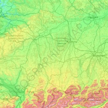
Name: Swabia topographic map, elevation, terrain.
Location: Swabia, Bavaria, Germany (47.27011 9.55057 49.03604 11.31157)
Average elevation: 670 m
Minimum elevation: 181 m
Maximum elevation: 2,865 m
Other topographic maps
Click on a map to view its topography, its elevation and its terrain.
Zugspitze
Germany > Bavaria > Landkreis Garmisch-Partenkirchen > Grainau
The mountain rises eleven kilometres southwest of Garmisch-Partenkirchen and just under six kilometres east of Ehrwald. The border between Germany and Austria runs over the west summit; thus the Zugspitze massif belongs to the German state of Bavaria and the Austrian state of Tyrol. The municipalities…
Average elevation: 2,300 m