
Thank you for supporting this site ❤️
Make a donation
Make a donation
Norton topographic map
Click on the map to display elevation.
Thank you for supporting this site ❤️
Make a donation
Make a donation
About this map
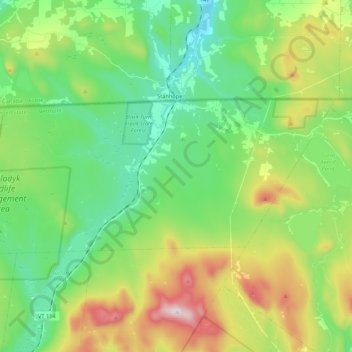
Name: Norton topographic map, elevation, terrain.
Location: Norton, Essex County, Vermont, United States (44.94460 -71.91193 45.01142 -71.69776)
Average elevation: 541 m
Minimum elevation: 321 m
Maximum elevation: 1,010 m
Thank you for supporting this site ❤️
Make a donation
Make a donation