
Le Mazel topographic map
Interactive map
Click on the map to display elevation.
About this map
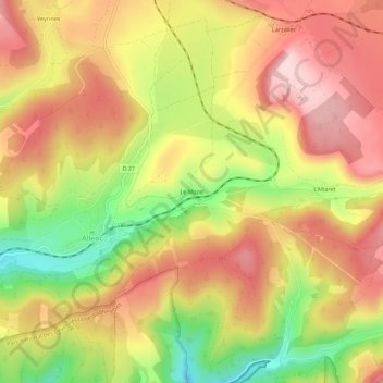
Name: Le Mazel topographic map, elevation, terrain.
Average elevation: 1,151 m
Minimum elevation: 989 m
Maximum elevation: 1,271 m
Other topographic maps
Click on a map to view its topography, its elevation and its terrain.
Ruisseau de la Valette
France > Occitanie > Lozère > Allenc
Ruisseau de la Valette, Le Mazas, Allenc, Mende, Lozère, Occitanie, France métropolitaine, 48190, France
Average elevation: 1,195 m
Le Mas Planti
France > Occitanie > Lozère > Allenc
Le Mas Planti, Allenc, Mende, Lozère, Occitanie, France métropolitaine, 48190, France
Average elevation: 1,124 m