
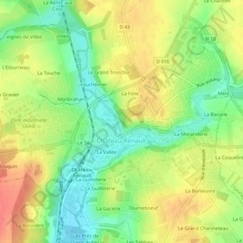
Château-Renault topographic map
Interactive map
Click on the map to display elevation.
About this map
Name: Château-Renault topographic map, elevation, terrain.
Average elevation: 112 m
Minimum elevation: 83 m
Maximum elevation: 141 m
Château-Renault is located on the Far-West of the Gâtine Tourangelle plateau, next to the Loir-et-Cher department and at the confluence of two rivers. The Gault and the Brenne. Its Elevation vary between 90 meters and 140 meters on the plateau. The area of the commune is 3.51 square kilometre.