
Weißenburg i. Bay. topographic map
Interactive map
Click on the map to display elevation.
About this map
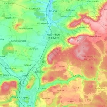
Name: Weißenburg i. Bay. topographic map, elevation, terrain.
Average elevation: 490 m
Minimum elevation: 386 m
Maximum elevation: 637 m
Other topographic maps
Click on a map to view its topography, its elevation and its terrain.
Absberg
Allemagne > Bavière > Weissenburg-Gunzenhausen
Absberg, Gunzenhausen (VGem), Weissenburg-Gunzenhausen, Bavière, 91720, Allemagne
Average elevation: 443 m
Weißenburg in Bayern
Allemagne > Bavière > Weissenburg-Gunzenhausen > Weißenburg i. Bay. > Weißenburg in Bayern
Weißenburg in Bayern, Weißenburg i. Bay., Weissenburg-Gunzenhausen, Bavière, 91781, Allemagne
Average elevation: 474 m
Treuchtlingen
Allemagne > Bavière > Weissenburg-Gunzenhausen
Treuchtlingen, Weissenburg-Gunzenhausen, Bavière, 91757, Allemagne
Average elevation: 504 m