
Oberharz am Brocken topographic map
Interactive map
Click on the map to display elevation.
About this map
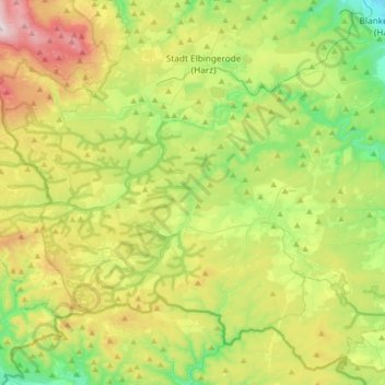
Name: Oberharz am Brocken topographic map, elevation, terrain.
Average elevation: 512 m
Minimum elevation: 215 m
Maximum elevation: 1,043 m
Other topographic maps
Click on a map to view its topography, its elevation and its terrain.
Brocken
Deutschland > Sachsen-Anhalt > Landkreis Harz > Wernigerode
Brocken, Wernigerode, Landkreis Harz, Sachsen-Anhalt, Deutschland
Average elevation: 963 m
Halberstadt
Deutschland > Sachsen-Anhalt > Landkreis Harz > Halberstadt
Halberstadt, Landkreis Harz, Sachsen-Anhalt, Deutschland
Average elevation: 149 m