
Reutti topographic map
Interactive map
Click on the map to display elevation.
About this map
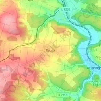
Name: Reutti topographic map, elevation, terrain.
Average elevation: 637 m
Minimum elevation: 562 m
Maximum elevation: 715 m
Other topographic maps
Click on a map to view its topography, its elevation and its terrain.
Auen
Deutschland > Baden-Württemberg > Alb-Donau-Kreis > Schelklingen
Auen, Schelklingen, Alb-Donau-Kreis, Baden-Württemberg, 89601, Deutschland
Average elevation: 593 m