
Narendranagar topographic map
Interactive map
Click on the map to display elevation.
About this map
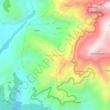
Name: Narendranagar topographic map, elevation, terrain.
Average elevation: 851 m
Minimum elevation: 447 m
Maximum elevation: 1,475 m
Other topographic maps
Click on a map to view its topography, its elevation and its terrain.
Byasi
India > Uttarakhand > Narendra Nagar
Byasi, Narendra Nagar, Tehri Garhwal District, Uttarakhand, India
Average elevation: 712 m
Dhalwala park
India > Uttarakhand > Narendra Nagar
Dhalwala park, Dhalwala,Rishikesh,Uttarakhand 249201, Dhalwala, Narendra Nagar, Tehri Garhwal District, Uttarakhand, 249201, India
Average elevation: 390 m
Agrakhal
India > Uttarakhand > Narendra Nagar
Agrakhal, Narendra Nagar, Tehri Garhwal, Uttarakhand, 249175, India
Average elevation: 1,265 m
Gaja
India > Uttarakhand > Narendra Nagar
Gaja, Narendra Nagar, Tehri Garhwal, Uttarakhand, India
Average elevation: 1,599 m