
Thank you for supporting this site ❤️
Make a donation
Make a donation
Strinz-Margarethä topographic map
Click on the map to display elevation.
Thank you for supporting this site ❤️
Make a donation
Make a donation
Strinz-Margarethä
Strinz-Margarethä liegt im westlichen Hintertaunus am Mittellauf des Aubachs. Die Gemarkungsfläche beträgt 890 Hektar, davon sind 424 Hektar bewaldet. Der Höhenzug, auf dem die Eisenstraße verläuft, bildet die westliche und die von Hennethal nach Idstein führende, als Hermannsweg bekannte Höhenstraße, die nördliche Gemarkungsgrenze. In der Ortsmitte treffen sich die Landesstraßen L 3032 und L 3274
Thank you for supporting this site ❤️
Make a donation
Make a donation
About this map
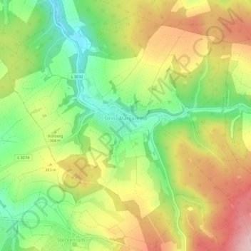
Name: Strinz-Margarethä topographic map, elevation, terrain.
Average elevation: 359 m
Minimum elevation: 257 m
Maximum elevation: 473 m
Thank you for supporting this site ❤️
Make a donation
Make a donation
Other topographic maps
Click on a map to view its topography, its elevation and its terrain.
Burg Hohenstein
Deutschland > Hessen > Rheingau-Taunus-Kreis > Hohenstein > Burg Hohenstein
Average elevation: 338 m