
Thank you for supporting this site ❤️
Make a donation
Make a donation
Langtoft topographic map
Click on the map to display elevation.
Thank you for supporting this site ❤️
Make a donation
Make a donation
About this map
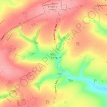
Name: Langtoft topographic map, elevation, terrain.
Location: Langtoft, East Riding of Yorkshire, England, United Kingdom (54.07078 -0.49688 54.10888 -0.41733)
Average elevation: 119 m
Minimum elevation: 40 m
Maximum elevation: 167 m
Thank you for supporting this site ❤️
Make a donation
Make a donation
Other topographic maps
Click on a map to view its topography, its elevation and its terrain.
Londesborough
United Kingdom > England > East Riding of Yorkshire > Londesborough
Average elevation: 73 m
Thank you for supporting this site ❤️
Make a donation
Make a donation