
Thank you for supporting this site ❤️
Make a donation
Make a donation
Ahmadi topographic map
Click on the map to display elevation.
Thank you for supporting this site ❤️
Make a donation
Make a donation
About this map
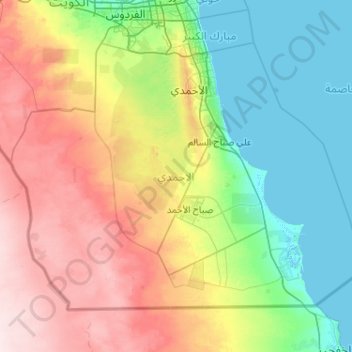
Name: Ahmadi topographic map, elevation, terrain.
Location: Ahmadi, Kuwait (28.52436 47.53925 29.20870 48.56721)
Average elevation: 82 m
Minimum elevation: -4 m
Maximum elevation: 246 m
Thank you for supporting this site ❤️
Make a donation
Make a donation
Other topographic maps
Click on a map to view its topography, its elevation and its terrain.