
La Pampilla topographic map
Interactive map
Click on the map to display elevation.
About this map
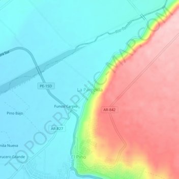
Name: La Pampilla topographic map, elevation, terrain.
Location: La Pampilla, Punta de Bombón, Islay, Arequipa, Perú (-17.16983 -71.80580 -17.12983 -71.76580)
Average elevation: 85 m
Minimum elevation: 14 m
Maximum elevation: 222 m
Other topographic maps
Click on a map to view its topography, its elevation and its terrain.
Catas
Perú > Arequipa > Punta de Bombón
Catas, Punta de Bombón, Islay, Arequipa, Perú
Average elevation: 8 m