
Thank you for supporting this site ❤️
Make a donation
Make a donation
Varese topographic map
Click on the map to display elevation.
Thank you for supporting this site ❤️
Make a donation
Make a donation
About this map
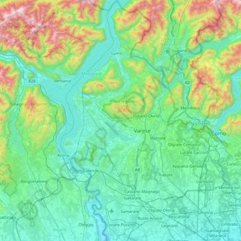
Name: Varese topographic map, elevation, terrain.
Location: Varese, Lombardy, Italy (45.55831 8.55225 46.12226 9.06630)
Average elevation: 521 m
Minimum elevation: 142 m
Maximum elevation: 2,252 m
Thank you for supporting this site ❤️
Make a donation
Make a donation
Other topographic maps
Click on a map to view its topography, its elevation and its terrain.
Thank you for supporting this site ❤️
Make a donation
Make a donation
Thank you for supporting this site ❤️
Make a donation
Make a donation