
Thenay topographic map
Interactive map
Click on the map to display elevation.
About this map
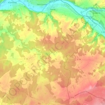
Name: Thenay topographic map, elevation, terrain.
Average elevation: 152 m
Minimum elevation: 90 m
Maximum elevation: 198 m
Other topographic maps
Click on a map to view its topography, its elevation and its terrain.
Éguzon
Frankrijk > Centre-Val de Loire > Indre > Éguzon-Chantôme
Éguzon, Éguzon-Chantôme, Châteauroux, Indre, Centre-Val de Loire, Metropolitaans Frankrijk, 36270, Frankrijk
Average elevation: 255 m
Mouhet
Frankrijk > Centre-Val de Loire > Indre
Mouhet, Le Blanc, Indre, Centre-Val de Loire, Metropolitaans Frankrijk, 36170, Frankrijk
Average elevation: 292 m
La Fouchette
Frankrijk > Centre-Val de Loire > Indre > Levroux
La Fouchette, Saint-Pierre-de-Lamps, Levroux, Châteauroux, Indre, Centre-Val de Loire, Metropolitaans Frankrijk, 36110, Frankrijk
Average elevation: 152 m
Saint-Genou
Frankrijk > Centre-Val de Loire > Indre
Saint-Genou, Châteauroux, Indre, Centre-Val de Loire, Metropolitaans Frankrijk, 36500, Frankrijk
Average elevation: 118 m
Nohant-Vic
Frankrijk > Centre-Val de Loire > Indre > Nohant-Vic
Nohant-Vic, La Châtre, Indre, Centre-Val de Loire, Metropolitaans Frankrijk, 36400, Frankrijk
Average elevation: 217 m
Villedieu-sur-Indre
Frankrijk > Centre-Val de Loire > Indre > Villedieu-sur-Indre
Villedieu-sur-Indre, Châteauroux, Indre, Centre-Val de Loire, Metropolitaans Frankrijk, 36320, Frankrijk
Average elevation: 142 m