
South Luangwa National Park topographic map
Interactive map
Click on the map to display elevation.
About this map
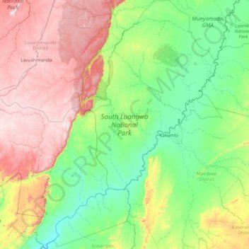
Name: South Luangwa National Park topographic map, elevation, terrain.
Location: South Luangwa National Park, Muchinga Province, Zambia (-13.77835 30.98753 -12.32451 32.12391)
Average elevation: 854 m
Minimum elevation: 473 m
Maximum elevation: 1,737 m
The park spans two eco-regions, both of them woodland savannah, distinguished by the dominant tree: Southern Miombo woodlands cover the higher slopes of the valley, while Zambezian and Mopane woodlands cover the bottom of the valley. The Mopane tree tolerates the higher temperatures and lower rainfall found at lower elevations than miombo trees which are found on the higher plateau. Within these woodland savannahs are larger patches of grassland, so that grazers such as zebra and leaf browsers such as giraffe are found in profusion in the same areas. Patches of flooded grassland habitats (floodplains) are found close to the river, on which hippopotamus graze at night. Their dung released into the river fertilises its waters and sustains the fish population which in turn sustains the crocodiles.
Other topographic maps
Click on a map to view its topography, its elevation and its terrain.
Mpika
Zambia > Muchinga Province > Mpika
Mpika, Mpika District, Muchinga Province, Zambia
Average elevation: 1,356 m
Chambeshi
Zambia > Muchinga Province > Chambeshi
Chambeshi, Muchinga Province, Zambia
Average elevation: 1,192 m