
La Forêt topographic map
Interactive map
Click on the map to display elevation.
About this map
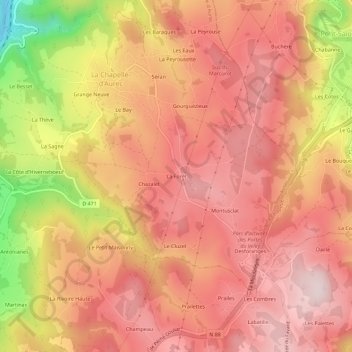
Name: La Forêt topographic map, elevation, terrain.
Average elevation: 697 m
Minimum elevation: 425 m
Maximum elevation: 826 m
Other topographic maps
Click on a map to view its topography, its elevation and its terrain.
Séran
France > Auvergne-Rhône-Alpes > Haute-Loire > La Chapelle-d'Aurec
Séran, La Chapelle-d'Aurec, Yssingeaux, Haute-Loire, Auvergne-Rhône-Alpes, France métropolitaine, 43120, France
Average elevation: 661 m
Grange Neuve
France > Auvergne-Rhône-Alpes > Haute-Loire > La Chapelle-d'Aurec
Grange Neuve, La Chapelle-d'Aurec, Yssingeaux, Haute-Loire, Auvergne-Rhône-Alpes, France métropolitaine, 43120, France
Average elevation: 637 m