
Cluny topographic map
Interactive map
Click on the map to display elevation.
About this map
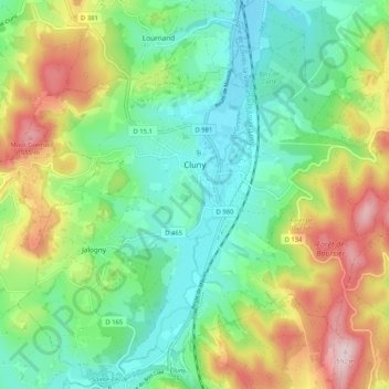
Name: Cluny topographic map, elevation, terrain.
Average elevation: 348 m
Minimum elevation: 225 m
Maximum elevation: 583 m
Other topographic maps
Click on a map to view its topography, its elevation and its terrain.
Louhans
Frankreich > Burgund und Freigrafschaft > Saône-et-Loire
Louhans, Saône-et-Loire, Burgund und Freigrafschaft, Metropolitanes Frankreich, 71500, Frankreich
Average elevation: 189 m
Paray-le-Monial
Frankreich > Burgund und Freigrafschaft > Saône-et-Loire > Paray-le-Monial
Paray-le-Monial, Charolles, Saône-et-Loire, Burgund und Freigrafschaft, Metropolitanes Frankreich, 71600, Frankreich
Average elevation: 265 m
Laives
Frankreich > Burgund und Freigrafschaft > Saône-et-Loire > Laives
Laives, Chalon-sur-Saône, Saône-et-Loire, Burgund und Freigrafschaft, Metropolitanes Frankreich, 71240, Frankreich
Average elevation: 197 m