
Trins topographic map
Interactive map
Click on the map to display elevation.
About this map
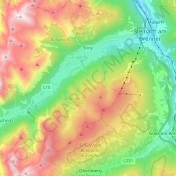
Name: Trins topographic map, elevation, terrain.
Location: Trins, Bezirk Innsbruck-Land, 6152, Oostenrijk (47.01515 11.34182 47.10919 11.46211)
Average elevation: 1,706 m
Minimum elevation: 1,014 m
Maximum elevation: 2,706 m
Other topographic maps
Click on a map to view its topography, its elevation and its terrain.
Padaun
Oostenrijk > Bezirk Innsbruck-Land
Padaun, Vals, Bezirk Innsbruck-Land, 6154, Oostenrijk
Average elevation: 1,653 m
Milders
Oostenrijk > Bezirk Innsbruck-Land > Neustift im Stubaital
Milders, Neustift im Stubaital, Bezirk Innsbruck-Land, 6167, Oostenrijk
Average elevation: 1,448 m
Hall in Tirol
Oostenrijk > Bezirk Innsbruck-Land
Hall in Tirol, Bezirk Innsbruck-Land, Oostenrijk
Average elevation: 648 m
Seefeld in Tirol
Oostenrijk > Bezirk Innsbruck-Land
Seefeld in Tirol, Bezirk Innsbruck-Land, 6100, Oostenrijk
Average elevation: 1,303 m