
Thank you for supporting this site ❤️
Make a donation
Make a donation
Mezzano topographic map
Click on the map to display elevation.
Thank you for supporting this site ❤️
Make a donation
Make a donation
About this map
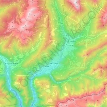
Name: Mezzano topographic map, elevation, terrain.
Average elevation: 1,363 m
Minimum elevation: 499 m
Maximum elevation: 2,522 m
Thank you for supporting this site ❤️
Make a donation
Make a donation
Other topographic maps
Click on a map to view its topography, its elevation and its terrain.
Nanno
Italy > Trentino-Alto Adige/Südtirol > Provincia di Trento > Ville d'Anaunia
Average elevation: 534 m