
Altastenberg topographic map
Interactive map
Click on the map to display elevation.
About this map
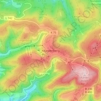
Name: Altastenberg topographic map, elevation, terrain.
Average elevation: 708 m
Minimum elevation: 564 m
Maximum elevation: 844 m
Altastenberg is een dorp in de gemeente Winterberg in Duitsland. Het dorp ligt op bijna 800 m hoogte in het Sauerland, zo'n 2 km ten noordwesten van de Kahler Asten.
Other topographic maps
Click on a map to view its topography, its elevation and its terrain.
Lenneplätze
Duitsland > Noordrijn-Westfalen > Hochsauerlandkreis > Winterberg > Neuastenberg
Lenneplätze, Neuastenberg, Winterberg, Hochsauerlandkreis, Noordrijn-Westfalen, Duitsland
Average elevation: 699 m