
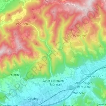
Sankt Lorenzen im Mürztal topographic map
Interactive map
Click on the map to display elevation.
About this map
Name: Sankt Lorenzen im Mürztal topographic map, elevation, terrain.
Average elevation: 842 m
Minimum elevation: 514 m
Maximum elevation: 1,365 m
Das Zentrum von Sankt Lorenzen liegt auf einer Höhe von 560 m ü. A., der höchste Punkt auf dem Gemeindegebiet ist der im Norden gelegene Töllmarkogel mit 1366 m.