
Neumünster topographic map
Interactive map
Click on the map to display elevation.
Neumünster
1871 wurde die Holstenschule als Privatschule für Jungen aus dem höheren Bürgerstand gegründet. Auch die Gründung der Privaten Höheren Mädchenschule, die heute Klaus-Groth-Schule Neumünster heißt und seit 1925 staatlich ist, fiel in diese Zeit.
About this map
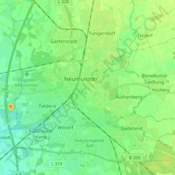
Name: Neumünster topographic map, elevation, terrain.
Location: Neumünster, Schleswig-Holstein, 24534, Deutschland (54.03574 9.94154 54.11574 10.02154)
Average elevation: 25 m
Minimum elevation: 11 m
Maximum elevation: 50 m