Geolocate

Alcaraz topographic map

Click on the map to display elevation.

Alcaraz

El relieve del municipio está definido por las estribaciones orientales del Campo de Montiel, la sierra del Relumbrar al oeste, que supera los 1100 m de altitud, el valle del río Guadalmena al sur, que nace en el territorio por la unión del río de El Escorial y el río del Horcajo, y por la sierra de Alcaraz al este y sureste. La altitud del municipio oscila entre los 1744 m en un exclave en plena sierra de Alcaraz y los 740 m a orillas del río Guadalmena. La ciudad se alza a 940 m sobre el nivel del mar.

Wikipedia (CC-BY-SA 3.0)

About this map

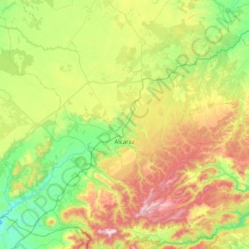
Name: Alcaraz topographic map, elevation, terrain.

Location: Alcaraz, Albacete, Castilla-La Mancha, España (38.49134 -2.76550 38.89816 -2.20043)

Average elevation: 1,034 m

Minimum elevation: 675 m

Maximum elevation: 1,760 m

Other topographic maps

Click on a map to view its topography, its elevation and its terrain.

Guajaraz

España > Castilla-La Mancha > Argés

Average elevation: 605 m

Caraquiz

España > Castilla-La Mancha

Average elevation: 713 m

Huertos de Moya

España > Castilla-La Mancha

Average elevation: 1,038 m

Covatilla

España > Castilla-La Mancha > Cuenca

Average elevation: 984 m

Cerro

España > Castilla-La Mancha > Fuentealbilla > Bormate

Average elevation: 660 m

La Nava

España > Castilla-La Mancha > Jadraque

Average elevation: 1,029 m

La Alcarria

España > Castilla-La Mancha > Bujalaro

Average elevation: 994 m

Río Sorbe

España > Castilla-La Mancha > Humanes

Average elevation: 842 m

Nava de Arriba

España > Castilla-La Mancha > Pozohondo

Average elevation: 874 m

Hoya del Portillo

España > Castilla-La Mancha > Talayuelas

Average elevation: 1,036 m

Cascada

España > Castilla-La Mancha > Mantiel

Average elevation: 910 m

Cobatilla

España > Castilla-La Mancha > Corduente > Aragoncillo

Average elevation: 1,266 m

Pico Padrón

España > Castilla-La Mancha > Bienservida

Average elevation: 1,376 m

Tiñosa

España > Castilla-La Mancha > Cantalojas

Average elevation: 1,717 m

Tajuña

España > Castilla-La Mancha > Maranchón

Average elevation: 1,269 m

Cedena

España > Castilla-La Mancha > Los Navalucillos

Average elevation: 1,083 m

Torcón

España > Castilla-La Mancha > Menasalbas

Average elevation: 741 m

Laguna de Uña

España > Castilla-La Mancha > Uña

Average elevation: 1,231 m

La Toja

España > Castilla-La Mancha > Villarrubio

Average elevation: 814 m

Cerro de la Mina

España > Castilla-La Mancha > Tortuero

Average elevation: 949 m

Cabeza Grande

España > Castilla-La Mancha > Cantalojas

Average elevation: 1,479 m

La Zarza

España > Castilla-La Mancha > Pozuelo

Average elevation: 931 m

El Conillo

España > Castilla-La Mancha > Cuenca

Average elevation: 1,609 m

Campillejo

España > Castilla-La Mancha > Campillo de Ranas

Average elevation: 1,123 m

Mesones

España > Castilla-La Mancha

Average elevation: 843 m

Taracena

España > Castilla-La Mancha > Guadalajara

Average elevation: 762 m

La Yunquera

España > Castilla-La Mancha > Lezuza

Average elevation: 821 m

Cuerda de la Melera

España > Castilla-La Mancha > Yeste

Average elevation: 964 m

Pelegrina

España > Castilla-La Mancha > Sigüenza

Average elevation: 1,078 m

Manzaneruela

España > Castilla-La Mancha > Landete

Average elevation: 1,057 m

Cueva del Armentero

España > Castilla-La Mancha > Beteta

Average elevation: 1,178 m

Nohales

España > Castilla-La Mancha > Cuenca

Average elevation: 946 m

Las Tinadas

España > Castilla-La Mancha > Tomelloso

Average elevation: 712 m

Tortonda

España > Castilla-La Mancha > Alcolea del Pinar

Average elevation: 1,115 m

Cantoblanco

España > Castilla-La Mancha > Balsa de Ves

Average elevation: 688 m

Cancarix

España > Castilla-La Mancha > Hellín

Average elevation: 497 m

Alto del Hornillo

España > Castilla-La Mancha > Cantalojas

Average elevation: 1,597 m

Góntar

España > Castilla-La Mancha > Yeste

Average elevation: 1,078 m

Las Suertes

España > Castilla-La Mancha > Pioz

Average elevation: 868 m

El Chaparral

España > Castilla-La Mancha > Pioz

Average elevation: 871 m

La Pollata

España > Castilla-La Mancha > Ocentejo

Average elevation: 1,064 m

Sierra

España > Castilla-La Mancha > Tobarra

Average elevation: 588 m

La Pared

España > Castilla-La Mancha > Balsa de Ves

Average elevation: 724 m

El Sahuco

España > Castilla-La Mancha > Atienza

Average elevation: 1,142 m

Argamasón

España > Castilla-La Mancha > Albacete

Average elevation: 756 m

La Matanza

España > Castilla-La Mancha > Honrubia

Average elevation: 852 m

La Cabrera

España > Castilla-La Mancha > Sigüenza

Average elevation: 1,041 m

Tazona

España > Castilla-La Mancha > Socovos

Tazona se encuentra a una altitud de 702 m s. n. m.

Average elevation: 711 m

Gárgoles de Abajo

España > Castilla-La Mancha

Average elevation: 834 m

Alberche

España > Castilla-La Mancha

Average elevation: 367 m

Mojón de Moros

España > Castilla-La Mancha > Peñalén

Average elevation: 1,384 m

Los Tormillos

España > Castilla-La Mancha > Beteta

Average elevation: 1,375 m

Crucetas

España > Castilla-La Mancha > Víllora

Average elevation: 842 m

Pajares

España > Castilla-La Mancha > Sotorribas

Average elevation: 957 m

Alto de San Roque

España > Castilla-La Mancha > Ujados

Average elevation: 1,156 m

Sierra Bermeja

España > Castilla-La Mancha > Consuegra

Average elevation: 777 m