
Thank you for supporting this site ❤️
Make a donation
Make a donation
Nilakkal topographic map
Click on the map to display elevation.
Thank you for supporting this site ❤️
Make a donation
Make a donation
About this map
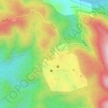
Name: Nilakkal topographic map, elevation, terrain.
Location: Nilakkal, Konni, Pathanamthitta, Kerala, India (9.38372 77.00071 9.40372 77.02071)
Average elevation: 338 m
Minimum elevation: 136 m
Maximum elevation: 537 m
Thank you for supporting this site ❤️
Make a donation
Make a donation
Other topographic maps
Click on a map to view its topography, its elevation and its terrain.